
SEVERE Tropical Cyclone Ita, Category 5, is expected to move in a general southwest direction towards the far north Queensland coast tonight and into Friday, while possibly intensifying further. That’s the advice at the Bureau of Meteorology website. 
Neil Hewett, who has contributed so many beautiful photographs to this website, and his beloved Cooper Creek Wilderness, are in the anticipated path of the cyclone.
I know Neil built the family home, nestled in the the oldest surviving rainforest on earth, with a cyclone bunker: a specially reinforced windowless pantry. That is where Neil and his family sheltered through Cyclone Yasi, a category five that hit the Daintree Rainforest in 2011.
Anyway, my thoughts will be with the Hewett family over the next couple of days.
Update: Hewett family and cassowaries survived Ita! Walking trails have already been cleared of debris and Cooper Creek Wilderness is back open for business. Neil expects that there will be increased flowering and fruiting over the next year, and perhaps even two breeding periods for the cassowaries, in response to the cyclone. More here…http://www.ccwild.com/enews/display.php?M=1776&C=46f0d1866283fd3d64930902be67673c&S=366&L=14&N=114
 Jennifer Marohasy BSc PhD is a critical thinker with expertise in the scientific method.

Good luck Neil. I hope it is not as bad as predicted.
It is interesting that with these 280kph winds they are talking about, at exposed coastal areas they only seem to be getting normal trade wind strength currently.
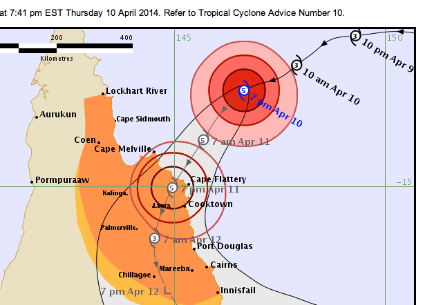
Cape Flattery ~ 20-25 kts and Willis Is, which, if you click on the radar is pretty close to Ita, a similar wind speed.
It doesn’t seem like Cat.5 from those reports.
Anyway, Neil, I hope that’s the case and all the best.
All the best to Neil and his family and all the other people in Ita’s path. Let’s hope it isn’t as bad as forecast.
All the best to our FNQ folk.
Let’s hope the BoM’s computer models are consistent and over estimate the effects of Global Warming.(It’s worse than we thought)
If anyone claims cyclone Ita is the fault of Global Warming, just remind them that it is further evidence that carbon(sic) taxes cannot stop weather. Or climate. Or Global Warming.
Ask them if they have any evidence otherwise.
I have two sisters up there. One at Cooktown the other at Daintree. They are both packing up and heading to Mossman. From there ?? Duno. I hope it heads away and fizzles.
Best wishes for safety of family, friends and community, as well as for the of property and habitat being impacted. That looks like quite a storm, but apparently this is a stormy region. It sounds like residents know what to do to be prepared.
Hi Jen,
Thanks for the kind thoughts and best wishes. No fury yet, at noon, but we’re as prepared as we can be.
Two weeks ago heavy rainfall took out our gravity-feed water supply and hydro-plant. We’re operating more inefficiently with the secondary systems, whilst new equipment is being fabricated. Copper underground phone-lines are still working, but they’re notoriously vulnerable to inundation and our broadband satellite has been painfully slow all morning.
On the positive side of things, there is nothing quite so enlivening to the life-giving qualities of a tropical rainforest as cyclones and the more forceful the disturbance the greater the return. We only hope that the structural integrity of the forest is up to the task.
Will let you know how things progress as the opportunities arise.
Thanks again for the kind wishes.
Thanks for update, Neil. Much valued.
Good luck to you and forest and critters.
Cape Flattery reading 993.6 hpa 35 miles from Ita’s centre indicates a small system if it’s cat5.
Cooktown reading 999.8 indicates likewise.
Let’s hope so.
Siliggy April 11th, 2014 at 9:21 am
“I hope it heads away and fizzles.”
You can send it over us before it fizzles. Putting up flood fences would be a welcome change!
Well, according to BOM it’s not quite what the media hype was suggesting. Winds at Cooktown seem relatively light at the moment. Cape Flattery, right underneath Ita, is registering around 100-130km/hr with gusts to 150 or so. About average-ish for a cyclone it seems to me, but I guess I could be wrong.
sp
this website seems to agree with you
http://earth.nullschool.net/#current/wind/isobaric/850hPa/overlay=wind_power_density/orthographic=145.86,-15.43,3000
doesn’t seem to rate the wind much over 131 km/h
At 8pm ITA made landfall at Cape Flattery according to the map. It was still rated as Cat.4 but atmo pressure was only 974.4 hpa [just under 28.8 inches of mercury] with wind speeds 65 to 85 knots.
Now down to 968.5 hpa at 8.35pm.
Shouldn’t be too much of a problem unless it goes back out to sea for more ammunition.
At 10pm Ita was still sitting over Cape Flattery and still rated Cat. 4. Baro pressure went down to 961.9 [about 28.4 inches of mercury] at 9.34pm but has come back to 963.2 and the winds have not increased over the last hour. Max 86 knots at 8.52pm but averaging around 45-60 kts.
I can’t see how they can call Ita a Cat. 4 cyclone with these specs.
As we all know by now Ita made landfall as a cat.2 which is appropriate given wind speed and pressure;certainly lost a lot of energy.It must be bad news for the media!
Thank heavens that this system was only a cat 4 on landfall. It seems there wasn’t the damage as first thought and most importantly no loss of life.
And more good news is the finding of the little 3 year old girl in Qld as well. She seems okay, but I suppose time will tell. If she was taken let’s hope they quickly find the person responsible.
I must give credit to ABC 24 yesterday. They seemed to be reporting it straight and actually listed all the landfall cyclones in this area since about 1850.
They mentioned that 115? years ago at least 400 people lost their lives in boats etc in one of the worst cyclones to hit the area.
Yes Neville, that was cyclone Mahina in Bathurst Bay [quite close to Ita’s landfall] and those 400 people died when the population was very much less than today.
I heard where someone is writing a book about it and claims that a boat skipper recorded an almost unheard of 26 inHg low pressure during Mahina.
It makes you wonder how the BoM measure barometric pressure of cyclones like Ita when they are out at sea.
I’m sure it’s mostly guesswork, uncertainty and the precautionary principle.
What does that remind you of? ☺
Quite right Neville;category 4.Initial damage reports in Cooktown shire indicate that the area avoided a wipe-out-wind speeds were lower than expected.Still, Ita wound down quite quickly.Had the experience of Althea in 1971 whilst travelling through Ayr in my Kombi- lot of damage and the Bruce was not to be seen.
Well, it’s great that things weren’t as bad as predicted, however it did take the wind out of the media’s sails, so to speak. They were building up for a major disaster – I was watching Channel 7 last night and they did a live cross to Cooktown where the reporter was trying desperately to capture a sense of the danger as the trees waved gently in the background.
After days of headlines and live crosses and any number of experts prognosticating on how bad 300km/hr winds would be and what an enormous the storm surge was forming, as well as all the talk of Cooktown being destroyed, I awoke this morning to the news that Ita had left “5000 homes without power”.
On the TV now they are trying to whip up some fears about the impact on Port Douglas. Again with gently waving trees in the background…
Who is telling porkies?
Australian cyclone categories:
Category 1 Strongest gust less than 125 km/h
Category 2 Strongest gust 125 – 170 km/h
Category 3 Strongest gust 170 – 225 km/h
Category 4 Strongest gust 225 – 280 km/h
Category 5 Strongest gust More than 280 km/h
“NASA: April 10 at 0900 UTV/5 a.m. EDT
Ita’s maximum sustained winds were near 115 knots/132 mph/213 kph on April 10 at 0900 UTV/5 a.m. EDT, making it a Category Four hurricane on the Saffir-Simpson scale.”
The Weather Channel
Tropical Cyclone Ita made landfall Friday night, 11/4 with 10-minute average sustained winds around 105 mph [170 kph] between 9 and 10 p.m. local time, according to the Australia Bureau of Meteorology. This would equate to a Category 3 hurricane on the Saffir-Simpson Hurricane Wind Scale.
I think this fits here because it refers to SLR in island nations in our area.
http://blogs.news.com.au/heraldsun/andrewbolt/index.php/heraldsun/comments/martin_parkinson_shouldnt_be_so_quick_to_shout_global_warming/
Here we have a senior public servant forecasting a SLR that doesn’t seem to reflect observations at all. Hey but what’s new about that?
BTW we should remember the super cyclones that occurred in Nth Qld up until the early 19th century.
The ABC Catalyst program covered a 6,000 year study from James Cook uni and Bob Carter has also claimed that super cyclones existed during the LIA.
http://www.abc.net.au/catalyst/stories/s382613.htm
Good to hear the news about Neil and his family, but it still doesn’t stop some journos writing a load of BS about the future of cyclones in OZ.
They just make it up as they go along. Just like all of their nonsense about CAGW.
http://blogs.news.com.au/heraldsun/andrewbolt/index.php/heraldsun/comments/an_alarmists_evidence_22_boiled_eggs/
Yes Neil, that’s great news. Hope all the wildlife survived and is prospering.