
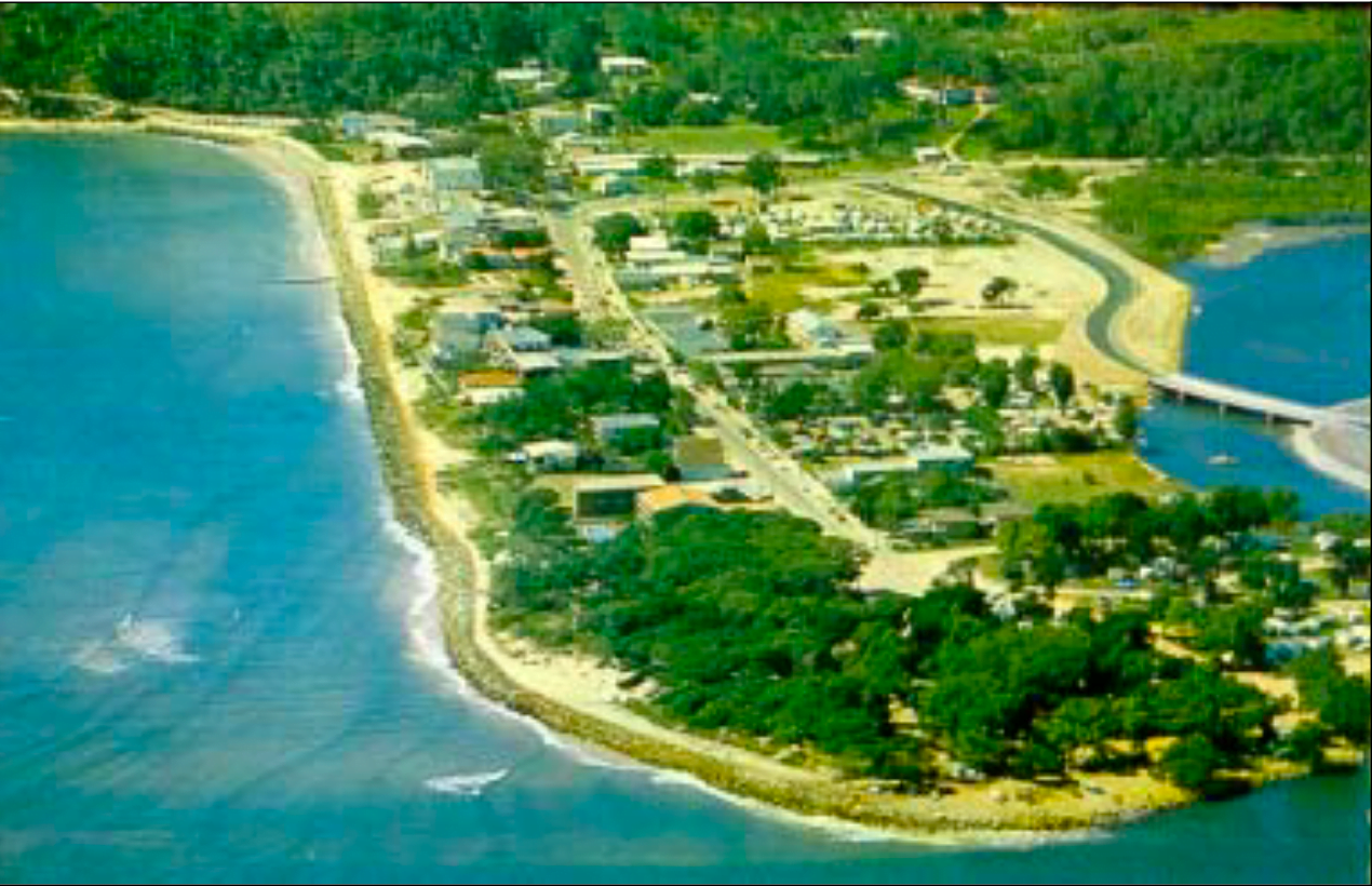
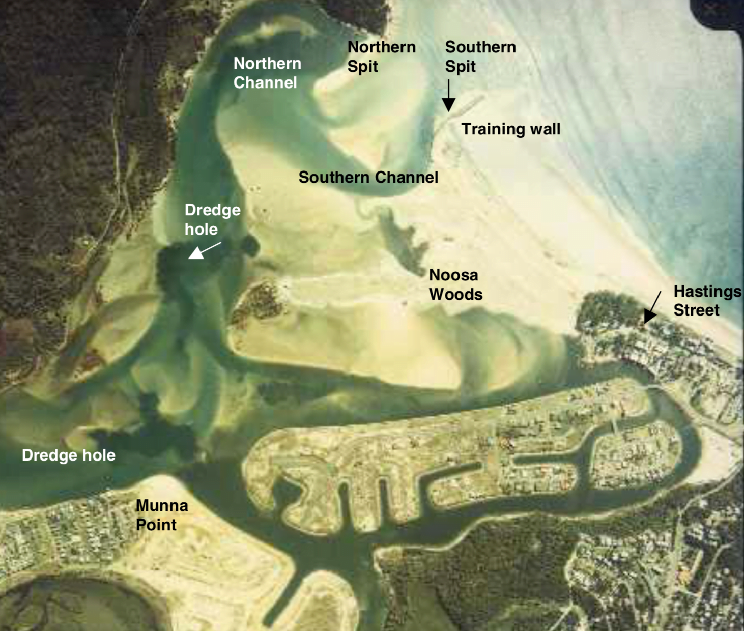
River mouths are ever changing with the seasons and with the tides, and they can also be completely changed through the building of rock walls. I remember Noosa’s river mouth back in 1973 when we lived in the caravan park, which was at the end of Hasting Street. Just beyond our caravan was the river mouth.
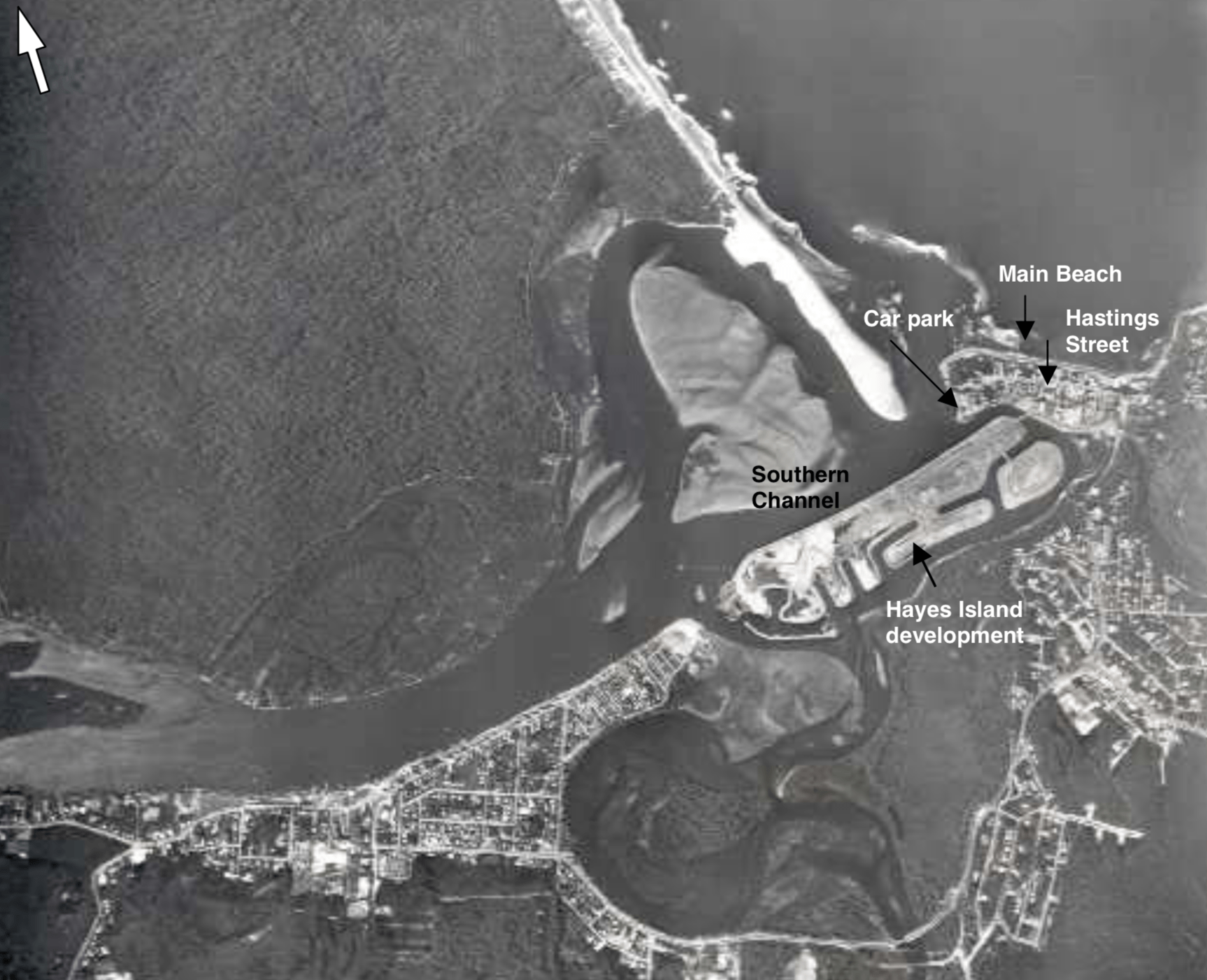
Now there is a winding road through what is called Noosa Spit, and then the river mouth. So, the southern side of the river’s mouth has been extended, perhaps 400 metres.
There is a report published back in 2006 by Chamberlain and Tomlinson with old aerial photographs that confirms how I remember it. What we now call Noosa Spit was, back then, on the other side of the river mouth.
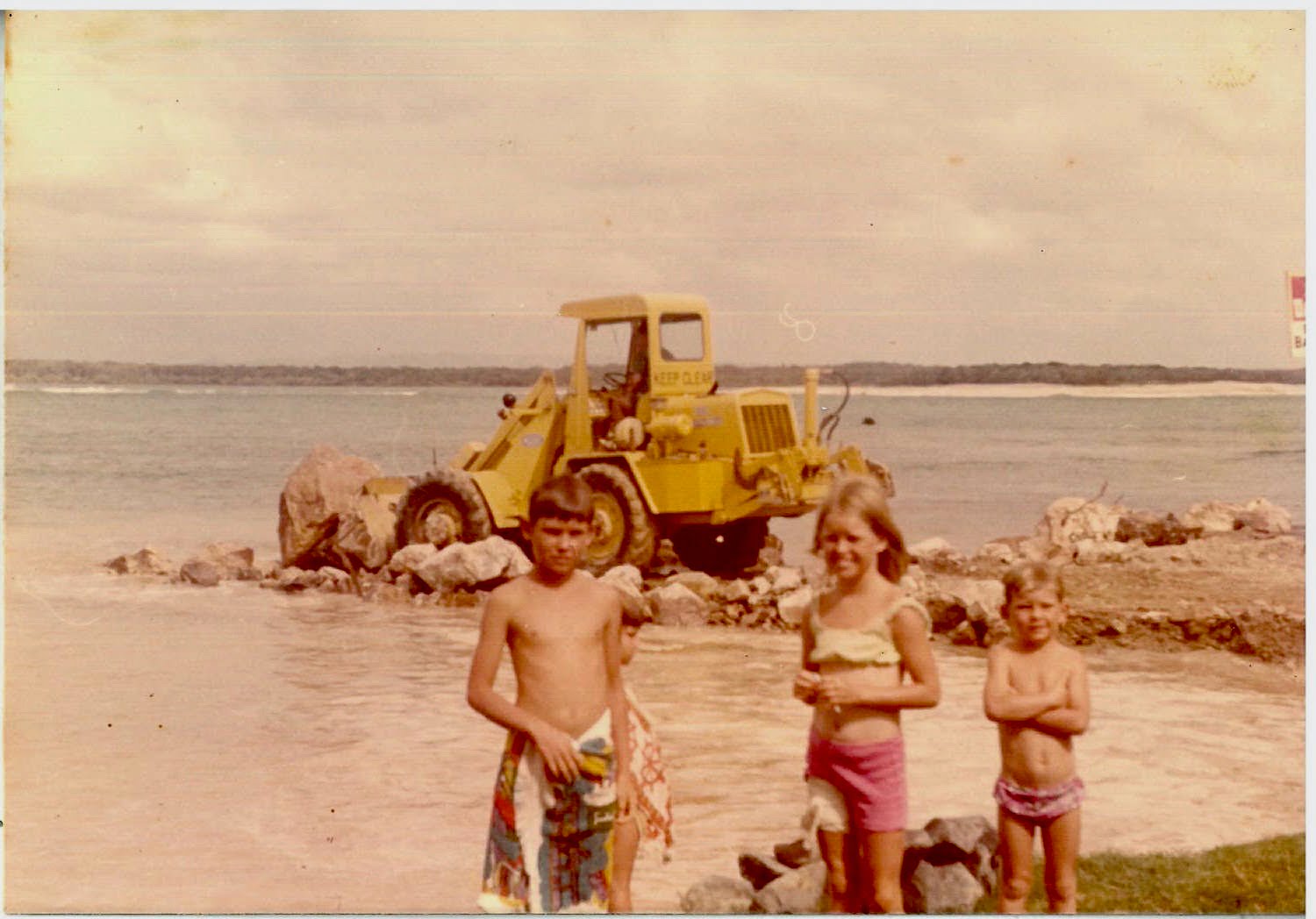
I remember when they first started dumping rocks, Mum took a photograph of me and my two brothers. That was back in 1973.
I was out taking video just yesterday (9 November 2020) of the river mouth. If you watch the video to the end you will see how I look today, in the orange jacket. Back in 1973, standing in the same place, I would have been standing about in the middle of the channel!
All the rock that has been dumped over the years has caused much more sand to shoal to the southern side of the river’s mouth, which is where most of the people are. In fact, the river has been ‘trained’ to shoal to the south, beginning in 1978 with the dumping of rocks into what was then the river mouth proper, far beyond the land. This is explained in the report, by Chamberlain and Tomlinson.
While we can be critical of all the changes to the Noosa river mouth that are man-made, for the most part it has given us more certainty and so many more trees. When ‘the spit’ was on the north shore/on the northern side of the river mouth it was just bare sand.
But what they have done at the bottom of the Murray River, now that is absurd. Back in the 1930s governments build 6.7 kilometres of sea dyke/barrages to try and stop the tides from entering the Murray River estuary, because the local council wanted the lower reaches of the Murray River to be permanent fresh. I have written much about the Murray River, and how so many Australia’s want to save it, yet they have no understanding of its natural history – not even whether the Murray River’s mouth is wave or tide dominated.
When we really care about something, we should think about first understanding it. That means we might need to take some time out, to watch and listen and even read. Of course, a best way to learn is to hear different perspectives and then to go see, to trust our own eyes and capacity to reason.
 Jennifer Marohasy BSc PhD is a critical thinker with expertise in the scientific method.

Jennifer, I do not know Noosa and the river entrance to the sea there. But I do know the River Murray mouth here in South Australia. Your 2012 study of the Murray mouth and the impact of the barrages ( to ensure that Adelaide gets fresh water ), is great science.
Mind you not many South Australians have thanked you for it. It shows up too many vested interests impacting the way water flows are managed in the Murray Darling basin
And what happens when decades of Murray River silt settles in the “freshwater” impoundment because it cannot be flushed out into the ocean.
I guess it will become increasingly shallow.
The shallower it gets, the warmer it gets. Between turbidity and temperature, tough luck for the wildlife. and never mind the increased risk of “lateral” flooding in the event of a bit of a surge down the river.
Between the pumping of Murray water to Melbourne (NO dams, you see) and this interference with the river mouth, things will get messy. Sadly, the guilty bastards will be dead or off-shore when that occurs, and in the time-honoured Australian tradition, the tax-payers will pick up the eye-watering bill for a zillion “consultants” and ” environmental engineers” to PERHAPS do the right thing, for once. Meanwhile, another army of public serpents writes vast tracts of regulations to muddy the already turbid “waters”.
I go back a bit further than you Jen. I was there before there was any mouth, & what is now estuary was totally isolated from the ocean by huge sand dunes, & a slightly brackish lake existed, much as the lakes now by the barrages.
It must have been 1946, when we had a holiday at Noosa when dad was demobbed from the WW11 airforce. During the first week dad would row a rented pulling boat down to the sand dunes to fish. The water must have been fairly salty as we caught whiting & flathead in the lake inside the dunes.
During the second week a cyclone came right down the coast. We could see the seas breaking over the sand dunes, & into the lake. On the 3Rd day the last of the dune collapsed, & the lake became an estuary.
Pity we don’t get cyclones in South Australia, that could open up the man made lakes to the sea turning them back into the estuary they were & should be now.
Hasbeen, So much thanks for sharing this memory! It seems that like so many east coast river mouths it used to once upon a time close over. Are there any now that are allowed to close over, most have groins and dredging to keep them permanently open?
@Bruce there are so many dams & locks on the Murray ( dozens ! ) that most of the silt carried by the Murray is caught upstream and never reaches Lake Alexandrina. But there are a couple of local rivers ( the Finness & Angas & Bremer ) that flow directly into the lake and deposit their silt loads.
Similarly, it used to be a feature of the Jumpinpin bar between North & South Stradbroke Islands where the shifts in the channel would drop trees into the channel thereby creating great shelter (and fishing) for the schools of bream that came through in winter months.
Dunno what it’s like now, haven’t lived in Qld for decades.
I expect there could be a “bream tax” in operation now, or the bar has been made a no-fishing reserve, or some other such greenie kill-joy measure has been brought in.
Hi Jen,
What a coincidence, that I just watched this yesterday. Made me long for the sea.
https://www.youtube.com/watch?v=X9fIy83xfeE
Hi Bruce,
About flooding, they are playing foolish games with the rivers again right now.
Limited irrigation allocations and Burrinjuck is at 95% and went up 2.4% in the last week, Blowering is at 86%, so the Murrumbidgee is on a bit of a knife edge, if we get a big rain. I suppose all that water is for the “viramut”, but floods never are. There were stories around 20 years ago that Burrinjuck should not be filled to the limit, except in emergencies and there was a warning system , for those downstream , if something went wrong. Seemed legit, as it was locals who told me.
River mouths are complex dynamic environments with constantly changing tides, river flows, sediment load, and wind influenced longshore drift. When people interfere with this environment they can cause much anthropogenic damage but because politicians would find it difficult to fill their pockets with this type of anthropogenic change it will not be a national or international topic.
Hello Jennifer,
On the south coast of NSW the Bega River mouth is often closed. The council opens it when the water backs up too much. I was fishing upstream in about 1982 when it was opened and the water level dropped over a metre very quickly. Google Earth shows it open when last photographed. Further north at Tuross Heads, Lake Coila has to be opened to the sea regularly to avoid flooding of the Princes Highway. Google Earth shows it closed.