ALWAYS in search of an ultimate truth, I’m rarely one to admit that everything is relative. When it comes to shorelines and the age of ‘wave cut platforms’, however, there is no escaping it … the relativism.
The sea and the climate are modelling our coastline as a sculptor might work a piece of clay … except over a longer time frame, and the shoreline is made of materials that are much tougher and much less consistent than clay. I’m specifically referring to the coastal sandstones, and also the granites, and even the igneous intrusions (from past volcanoes), along the coastal track from Main Beach at Noosa Heads to Hell’s Gates in Noosa National Park.
Geological time can be thought of in terms of the last few thousand years, the last few 100 thousand years, and also in terms of millions of years.
Over these periods sea levels along the east coast of Australia have risen, and fallen, and risen again. The factors causing the change in sea level over these time periods can be understood in terms of the varying orbits, tilts and wobbles of the Earth around the Sun, and also the varying levels of radiation emitted from the Sun. There are other factors. For example, varying declination of the moon may cause a 18.6 year pattern in sea levels. But this is unlikely to leave a mark on the shoreline … unless there are corals, as I will discuss at the Maroochydore Surf Lifesaving Club this Sunday*.
*****************************
If you are coming on Sunday, please book here: https://www.trybooking.com/book/event?eid=520591
******************************
Waves pound at cliff faces. Sometimes until they are cut back to sea level.
So, along the east coast of Australia – along the path I often walk from Hasting Street/Main beach to Hell’s Gates – and back, I find what are called by geologists ‘wave cut platforms’.
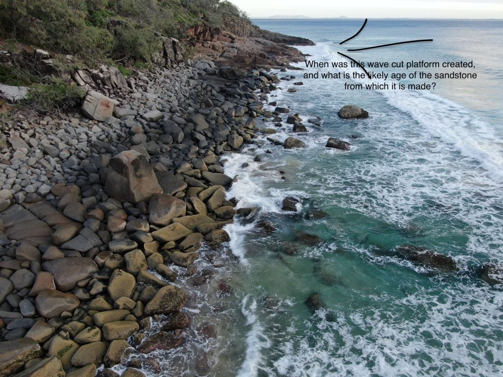
These ‘wave cut platforms’ exist where the sea has cut into the cliff face, creating a flat area that we would expect to be at sea level.
Well … we would expect the wave cut platform to be at sea level only if sea levels did not change.
If sea levels are rising then these platforms should be underwater.
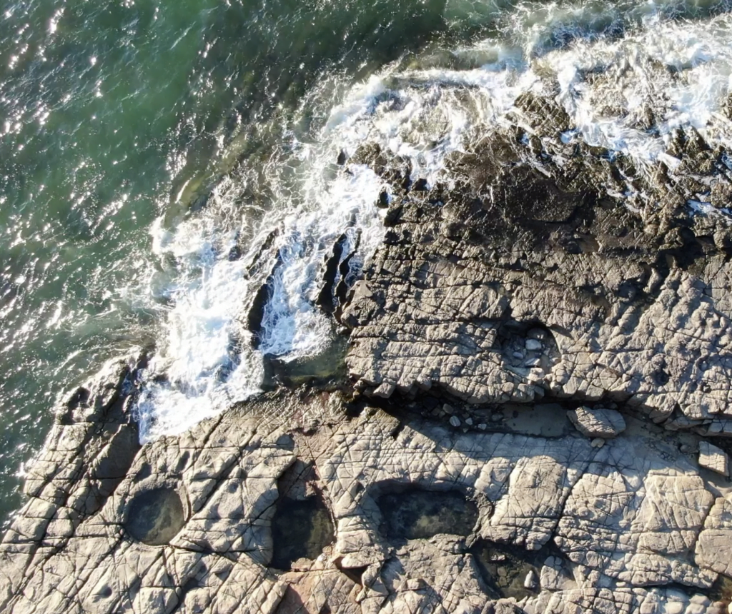
The potholes in the rock platform to the north of Tea Tree Bay are above the high tide mark. These holes in the sandstone are thought to be formed from boulders working as grinding stones in the surf, as explained in the comments thread of a previous blog post.
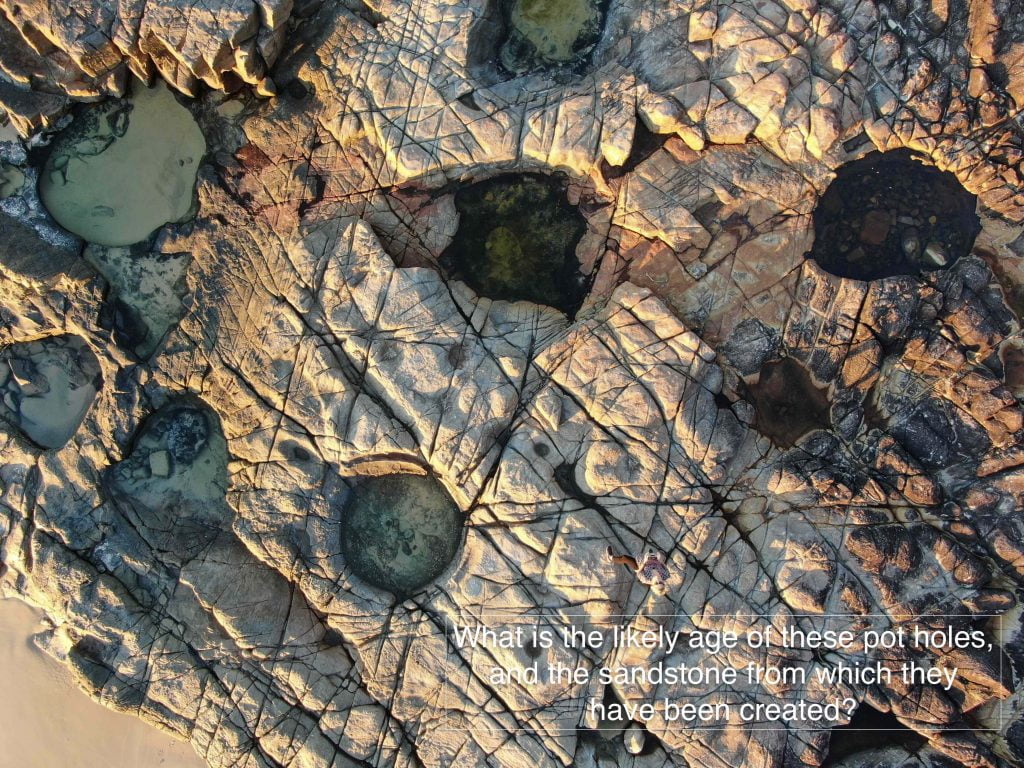
Mostly, I see wave cut platforms above sea level. Yet, the east coast of Australia is often defined by geologists as a “relatively young sea-coast” — for example in W.J. Dakin’s book entitled ‘Australian Seashores’.
Where there are rock platforms that are well defined, yet a couple of metres or so above the highest tides, is this perhaps evidence that sea levels have fallen relatively recently. But exactly when?
This blog post is partly a shout-out to knowledgeable geologists …
Considering the coastline in these pictures taken from my new drone (called Skido):
1. When are the sandstone platforms likely to have been cut by the waves?
2. Would the rock platform with the pot holes have been cut during the last inter-glacial period from perhaps 140,000 to 120,000 years ago?
3. Is there any evidence of the more recent Holocene high-stand, which I understand to have been about 6,000 years?
I understand that sea levels were about 2 metres higher 120,000 years ago, and about 1.5 metres higher 6,000 years ago?
According to Warwick Willmott’s book entitled ‘Rocks and Landscapes of the Sunshine Coast’ the headlands of Noosa, Coolum and Point Cartwright were islands during the last inter-glacial.
In between this last-interglacial and the beginning of the Holocene (some 11,600 years ago) we had a fall in the sea level of about 150 metres along the Sunshine Coast – I’m quoting again from Warwick Willmott.
I should like to take some photographs of the underwater platforms that are evidence of the 150 metre fall in sea level. So, how far off the coast will I need to send my drone?
*****************
UPDATE 11 JUNE 2019
I’ve walked over these potholes at high tide, and was sure the surf didn’t get that far … but I had to check, and get some photographs to be sure. So, I went this afternoon for what was a relatively high tide of 2.0 metres at 4.30pm. The highest for this year was 2.32 metres on 22nd January. The second highest will be on 1st August at 2.27 metres.
Anyway, following are three photographs (from today on the highest tide) to provide additional perspective.
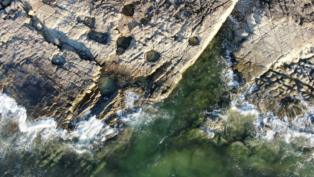
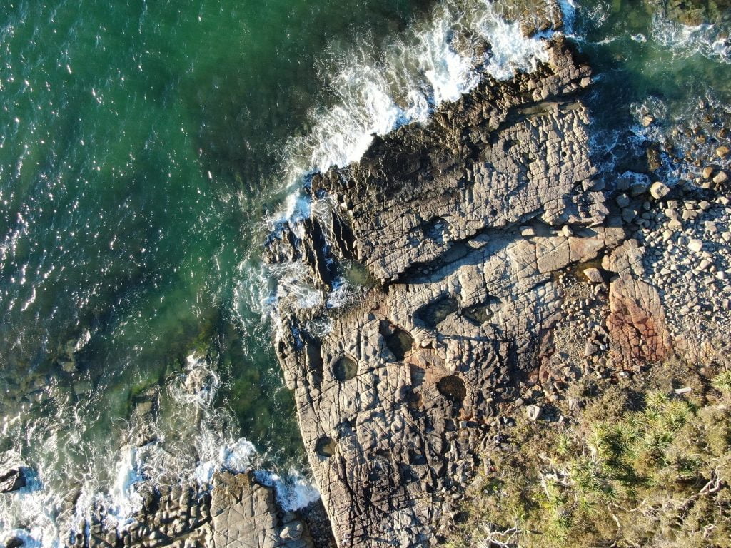 A photograph of the pot holes, on the very high tide today, 11th July 2019./caption]
****
*I shall be showing these photographs of rocky landscapes, and many more of corals, at the Maroochydore Surf Lifesaving Club this Sunday (14th July) at 2pm. Coral can give us an indication of sea level fall over much shorter time frames, for example, since 1950 as I will show on Sunday.
Everyone is welcome at the surf club, entry is $10, please register online here. The instructions are to go to Level 3, which is the Conference Room. The address is 36 Alexander Parade, Maroochydore. I’m told the $10 includes afternoon tea!

 Jennifer Marohasy BSc PhD is a critical thinker with expertise in the scientific method.

Jennifer, that is a great article. Thanks for putting it up and for going to the effort of doing the on ground research which enables the discussion.
A favourite place to visit for me is Port Elliot on the South coast of SA. There is a headland sticking out into the sea there with similar wave cut platforms.. I’ve often pondered the geological history of this area.. And how sea level rises and falls have created the coastline here in SA
I am not a geologist. So I have no comment or reply as regards your shout out to Geologists. But I hope that they respond and help you in this.
Thanks Jennifer, somehow geology isn’t widely known. Part of the problem is undoubtedly the jargon they use. The plant nurseries have to moderate the use of Latin binomials if they’re to make a living. Not necessarily the case for geologist doing oil exploration
The raised cockle beds around Corio bay aren’t very charismatic but intriguing as an exception to the rising seas narrative. In Vanuatu the uplifting coral reefs are more obvious as is the tectonic cause.
I’ve heard scuba divers remark on a limestone pavement 100’ down off Robe. Maybe the waves scrape it clean!
There’s some paywalled reference about a mantle plume under the east coast if I recall correctly
This recent article may hold part of the answer?
According to Professor Muller’s model, as Australia and Antarctica separated 150 million years ago, the eastern edge of our continent was dragged down as it collided with the Pacific plate to the east.
About 100 million years ago, this “subduction” process stopped, causing the eastern edge of Australia to rebound upwards between 400 and 600 metres.
Then 50 million years ago, Australia’s drift north accelerated dramatically to about seven centimetres a year. This saw the east of the continent straddle the edge of a Pacific mantle upwelling known as the Pacific Superswell.
This “superswell”, which more recently caused volcanic islands such as Tahiti and Fiji to form, led to a second uplift event in the Snowy Mountains of about 700 metres.
“The northern highlands [in present day Queensland] experienced a continuous history of uplift [from 100 million years ago] … The southern highlands [including the Snowy Mountains] started interacting with the edge of the large pacific upwelling about 40 to 50 million years later, resulting in a two-phase uplift history,” the report said.
The findings of Professor Muller’s team were published in Earth and Planetary Sciences.
https://www.smh.com.au/environment/kosciuszko-explained-mystery-of-the-snowy-mountains-solved-20160315-gnj2zg.html
The stranded shell beds indicate rather more recent uplift
@ Mike Lots of stranded shell & sandy raised ‘beaches’ with flat low lying formerly swampy areas in between, in the South East of SA !
By some quirk of language the locals call them ‘ranges’ but not like any mountain range I’ve ever seen.
Jennifer
Your mapping drone photos are really good. I love their sharpness and detail, excellent mapping. One point, however, and please don’t think this is negative – a good geo map needs both scale (your shadow helps here) and a *north* point or arrow. Just use a field compass and draw it on the drone photo.
>”Waves pound at cliff faces. Sometimes until they are cut back to sea level.”
Quite recently I had the fun of examining the chalk cliffs on the south-east UK coast (Hastings, Dover etc). The rate of wave-cut retreat on the clifflines is astonishing – about 5m per year. Medieval stone fence lines are abruptly cut off on the (now) cliff edges. There are air photos from the 1950’s showing the then waveline. Wave action at high tide across the platform undercuts the base of the cliff and large chunks, unceremoniously unsupported, just slab off. This is the same action as your Noosa clifflines, just enormously speeded up due to the softer chalk rock. The Noosa joint sets are critical here, determining the width of slab.
The potholes are the result of hard boulders (probably ice-rafted) dropping into the softer sand sediment during deposition, lithified in due course, then stirred around as the waves cut the platform down. Yes, the sea level has dropped since those holes were cut as they are now above high tide.
Rainbow Beach, about 40km north of Noosa, has a mapped fossil beach about 3m above current beach level and C-dated over 40k years ago. This is regarded as the probable highstand of the Pleistocene. [https://www.sciencedirect.com/science/article/pii/0031018279901536]
The rock suites are reportedly Mesozoic sandstones partially deposited over a granite emplacement and intruded by later (Triassic ?) igneous sets. From your drone photos, there appears to be a 3rd fracture set roughly E-W, indicating some degree of folding (metamorphism). This tectonism also alters the actual coastline level.
There are earlier wave-cut platforms now under water out east there, but covered in sediment from the constant northern current flows. Please don’t drop Skido in the briny 🙂
Warwick Willmott’s book is a good reference.
Hey Ian,
Thanks for this information, about the geology.
I have been very nervous about the drone ending-up in the sea and/or estuary, but I’m getting more confident with more flying hours.
As regards the mapping and ‘scale’ and ‘north point’ … I’ve just posted some photographs here at the blog. These photographs are not part of my ‘mapping’, which might perhaps best be described as photogrammetry.
I’m using a software package called Dronedeploy ( https://www.dronedeploy.com/ ) for the mapping/phogrammetry, which I haven’t mastered yet. When I have, I shall blog on it.
I’ve learnt how to program it based on Google Earth maps, and then sent Skido up to various altitudes with a predetermined flight path to takes hundreds of photographs, that the software package subsequently stitches together using AI into maps … all based on the WGS 84 Global Reference System.
These maps that I’ve made so far with this drone-based technology, maps of the seagrass beds in the Noosa estuary and also of Granite Bay bolders, enable me to measure area and elevation and so much more. GPS and the ‘north point’ are incorporated.
The most detailed and accurate study raised beaches over a 60 mile stretch of coastline is probably that undertaken by Consolidated Diamond Mines ltd. (CDM) in Namibia. The area studied starts at the mouth of the Orange River and goes northwards. Prospecting trenches dug through marine deposits at right angles to the shoreline and overlying windblown sand at regular intervals quickly determined the elevation of wave cut platforms with their marine deposits (and diamonds!). Longitudinal cross-sections of the raised beaches, parallel to the shoreline also indicated crustal warping that has occurred since the wave-cut platforms were formed. The 2 metre raised beach (least crustal warping) was dated at 6000-8000yrs old from carbon dating of shell fragments and also fragments of items associated with the human “Strand-loopers” (beach dwellers ). The highest raised beach at +35metres amsl appears to tie in with Miocene fossil bone deposits in river terrace deposits in the nearby Orange River. I recommend that anybody serious about raised beaches attempts to get a copy of these CDM reports since the raised beaches were closely studied and mined over many years.
Jennifer, as a geologist, I have always been curious about the rock cut platforms along the east coast and I have occasionally looked at whatever literature I can find about them in relation to sea levels, which is pretty scanty I must say. The general consensus seems to be that the sea levels were around two metres higher sometime about 4000 to 6000 years BP. This probably lead to the creation of the platforms and also the extensive dune systems we see today. This, of course only tells us about the relative sea level along the east coast but I think from what I have read, it was probably global.
Interestingly I have noticed evidence of the higher level in some of the Pacific islands as well, although it is dangerous to read too much into these because of tectonic activity.
These are just my own observations and readings, I haven’t done any research as such and the Holocene is not my area of knowledge, I like rocks that go ‘clunk’ when you whack them, not ‘squish’.
I don’t like ones that go ‘bing’ much either, they’re too hard.
>”I’ve learnt how to program it based on Google Earth maps, and then sent Skido up to various altitudes with a predetermined flight path to takes hundreds of photographs, that the software package subsequently stitches together using AI into maps … all based on the WGS 84 Global Reference System. ”
Fantastic. Google Earth is an undoubted enormous mapping boost.
I was doing a mapping project in central Siberia of all places (totally uninhabited area) and Google Earth gridded photos had such astonishing clarity that I could easily pick old tiny drillhole sites. I asked Russian colleagues why the satellite photos should be so clear. The answer: “The Soviets built silos (missile) in this area so any retaliation would hopefully avoid the major cities”. Tis an ill wind etc …
>”I’m using a software package called Dronedeploy ( https://www.dronedeploy.com/ ) for the mapping/phogrammetry, which I haven’t mastered yet. When I have, I shall blog on it. ”
Yes please. As you can tell, detailed, accurate mapping and consequent interpretation is one my deepest interests.
Hello Jennifer.
Interesting article. I think the most accurate sentence was your first. Everything is relative.
In geology it is very difficult to have absolute measurement of rock unit relitive to each other with any certainty. It’s almost always relative. Quite often, when geology is discussed on a regional scale the relative reference is sea level. Not that sea level is absolute, just that it’s an understandable and identifiable relative reference point.
Geological uplift (regardless of cause) is a powerful and pervasive force. It is the reason that there are marine fossils at the top of some of the worlds highest mountains.
In this context sea level is alway relative to the continental uplift occurring in the geological region and time being discussed. Resolving the scale of attribution to either factor is difficult. So the default description is almost always relative.
The abstracts of papers, that are the basis of the concept of the Holocene High Stand that I have read, almost always conform to this practice of reporting their attribution of observations as relative. There are exceptions and my impression is that the authors of such papers don’t understand the principle and certainly do not prove their attribution observations.
The problem then starts when other non geologist scientists, not understanding the relative principle interpret the papers attribution reporting as absolute sea level rise. They simply choose to ignor the word relative in the abstracts as if it is of no significance. Such an assumption is useful to glaciologist as it allows attribution of absolute sea level change to melting glaciers. And thus the prevailing paradigm of Holocene climate change and the modern hysteria of anthropogenic global warming climate change.
In my view the main cause of the relative sea level change that you are observing is continental uplift, with minor contribution from absolute sea level change (probably increasing).
You should consider me biased.
Just the same, making the argument for recent sea level fall based on wave cut platforms is dubious at best.
Best Regards
Anthony Lucas
Jen, you’ve probably seen the 80 papers on the Holocene high stand at notrickszone.
This is one of them:
Relative sea-level records preserved in Holocene beach-ridge strandplains – An example from tropical northeastern Australia
https://www.sciencedirect.com/science/article/pii/S0025322718305000
@Anthony Lucas. An immediate response !
By your logic the earth has ‘up lifted’ along this section of coast about 2 meters in 6000 years.
And when I think about that, I think ‘balls Anthony”. We would know from other evidence if this had happened.
Bill in Oz,12.49 PM.
An uplift of 2 meters over 6000 years is an annual rate of 0.3mm/ year in excess of sea level rise. This is a very mild rate relative to known rates of uplift that are occurring at places around the world today. If you are sceptical about the rate, I would suggest it is nothing extraordinary.
The argument as to if this is possible or not is one of geological theory. You can dismiss it if you please. But I am interested to know what other evidence you think might indicate the absence of crustal uplift, relative or absolute.
PS- My comment above does not negate the concept that sea level changes with regard to coral reefs. Just that at best it is relative not absolute.
Modern GPS enabled tide gauges are trying to resolve these problems.
But for the past, there is no solution.
@Anthony Lucas
Wave-cut platforms are evidence of earlier sea levels. Dating them is harder, so determination of individual recency is complex and relative. That point is made quite a few times in Jennifer’s article and the comments.
The closest dating to Noosa I could find (so far) is the fossil beach mapped at Rainbow Beach about 40k north of Noosa (reference above). This suggests that the Holocene highstand in that area was about 3m above the current sea level, perhaps 40k BP. This doesn’t exclude minor level changes, up and down, in the intervening period.
Iani, 4.17pm
Holocene high stand average is about 2.5 meters. So three meters sounds about right.
But the earliest stage of the Holocene, the Greenlandian, started 11700 years BP.
If you are looking at something around 40k BP you are not in the Holocene, you have moved into the last stage of the Pleistocene, known as the Tarantian.
Best
Right on Anthony Lucas. A non geologist making observations like in this article is not evidence of anything.
Thanks so much everyone for all this information.
And I’ve just posted three more photographs, see above at the end of the original blog post. So you can see how high the surf came at the relatively high tide today/this afternoon.
Also, if you are coming on Sunday, please book here: https://www.trybooking.com/book/event?eid=520591
I think the arguments over whether it is relative sea level or absolute sea level are irrelevant in relation to Jennifer’s request for information.
There is sufficient knowledge to say that the sea level along the east coast reached a maximum of about 2 metres above current levels around 6,000 years ago and remained at that point for some time before falling.
It is more than likely that this was when the wave cut platforms were formed. This highstand most likely also lead to the formation of the, often extensive, preserved dune systems that lie, at times, a considerable distance landward of the current beach and above current sea level.
I am only working from memory and would need to chase up references to confirm this.
@Bill in Oz The region in the South East of SA which you mentioned is referred to as the dunes and swales. The dunes are former coastal dunes and the swales are the swamps that formed between them. Having lived in the area I recall they extend 25 or 30 kms inland from the current coast, between Beachport and Kingston. In wet years there was a gradual flow of surface water in a NW direction into the south end of the Coorong Lakes. When the South East was opened up for farming, the Government cut drains directly to the coast in a number of places to drain this land. The Coorong Lakes were flushed out by this water and not by the River Murray as our governments and environmentalists seem to think. I’m not sure what caused the sea to recede to where it is today, but the old coastline is certainly an established fact.
Pat, some weeks ago I found an old booklet at an Op Shop about draining one of the big swamps down in the South East. The owner of the land cut a 3 kilometer channel through the ‘old’ rock hard ‘dune’ to do the draining.
I’ve put it on a bookshelf somewhere here and must find it again !
But, yes all those old dunes show that the sea has retreated over time to get to the current coastline. Changes in sea level were part of that process. But also the deposition of sand by sea currents off shore played a part.
The drainage must have been a serious undertaking. I read somewhere, perhaps in the Natural History of the South East how the main drain shifts about the same flow as the Murrumbidgee. Near Melbourne the former KooWeeRup swamp is said to be 1M lower because the peat soils oxidised after it was drained
I have found that booklet : its called The Woakwine Cutting by Murray McCourt. Published in 1987.
The Woakwine swamp ( 400 ha ) was drained by a deep cutting made through the Woakwine range, draining the water of the swamp into lake George near Beachport. in the South East. The cutting made looks to be about 20 meters ! Through an old hardened compacted sand dune !
Is anyone else still anticipating ‘Climate Change Refugees’: https://www.abc.net.au/news/2019-07-15/defence-lacks-overarching-strategy-for-climate-change-conflict/11304954
Yes. The climate refugees will come from the British Isles as the weather becomes miserable
Cool beach Jennifer. Didn’t know you had a drone. And I love the almost crystalline structure of the neighbouring rocky plateau. Very interesting. Will pass on to geologist friend.
What an amazing post. Your observations, comments and photos are very interesting.
The comments following are so insightful.
Please let us know how the presentation went.
Hi Jennifer
Excellent work.
If you want to see some well developed wave cut platforms, visit the various headlands at Caloundra. I mapped them for my Honours Thesis in Geology at UQ in 1970. But I was mainly interested in the geology of the underlying sandstones, well exposed here. I now live in Minyama.
Jennifer
I wonder if the Noosa local council consulted with you before they decided to issue a Climate Emergency ?
Reported today by the ABC
https://www.abc.net.au/news/2019-07-22/climate-change-affecting-property-prices-noosa-climate-emergency/11327474