LEADING climate scientists were not acknowledging “the pause” in global warming, even though it was very apparent in the satellite-based temperatures of the lower troposphere. That was until last month.
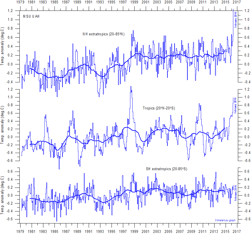
The February update to this satellite record has broken previous records for the northern hemisphere, and indicates that global temperatures are once again on the rise, Chart 1.

Some have attributed this warmth to an El Nino. Mean sea level pressures, and sea surface temperatures, are consistent with an El Nino, but not a super-El Nino that would result in record high temperatures.
Most of the warmth in the lower troposphere appears to have been recorded in the northern hemisphere, Chart 1 (top).
The super-El Nino in 1997, manifested as a record hot year in the tropics in 1998, Chart 1 (middle). This is what we might expect of an El Nino, which is often defined as extensive warming of the central and eastern tropical Pacific.
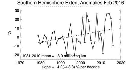
The apparent lack of warming in the southern hemisphere in February, could be due to the huge recent melt at the Antarctic. Yes, melt. While the Artic has been melting, there had been growth in the extent of ice at the Antarctic over recent years. Until February 2016, when it crashed, Chart 2.

A friend, Lance Pidgeon, emailed me: “The heat sucked into the melting ice would be a very large amount. It looks like the southern hemisphere sea ice anomaly went rapidly from about +1.8 million square kilometers to -0.5. This is 2.3 million of the total southern hemisphere area (255 million). Close enough to 1% of the area suddenly also began to absorb rather than reflect back due to the decrease in albedo.”
I can’t explain the apparent sudden surge in global warmth, and I don’t know anyone who predicted its magnitude.
Long range weather forecaster, Ken Ring, who bases his forecasts on lunar, solar and planetary cycles, correctly forecast the El Nino.
While the Australian Bureau of Meteorology started forecasting an El Nino from 2013, back in March 2014, Ken Ring is on record specifying that the next El Nino wouldn’t manifest until late 2015 to correspond with the minimum declination of the moon, and following what he predicted would be the year of Solar Minimum. For those interested in lunar cycles, a minimum declination occurs every 18.6 years, so the last one corresponded with the super El Nino of 1997/1998.
The late Bob Carter would assure us that climate always changes, and that the warming that occurred this February 2016 is still very much within the range of natural variability.
I’m not going to quibble with this, and global temperatures may be dropping again by April, once the El Nino has decayed. Nevertheless, the capacity of sceptics to thumb their nose at the scientific consensus by drawing attention to “the pause” has been dealt a blow by the recent melt at the Antarctic, and the February update to the Satellite record.


 Jennifer Marohasy BSc PhD is a critical thinker with expertise in the scientific method.

Any ice melting or heat spikes need the evil carbon (sic) gas caused by humans to lead:
Global energy-related carbon dioxide emissions (CO2) – the largest source of man-made greenhouse gas emissions – stayed flat for the second year in a row, according to analysis of preliminary data for 2015 released today by the International Energy Agency (IEA).
http://www.iea.org/newsroomandevents/pressreleases/2016/march/decoupling-of-global-emissions-and-economic-growth-confirmed.html
The El Nino was originally defined as an SST differential between Darwin and Tahiti, a result of the SOI variance, and was called off on by the agencies at the end of a given year. A result cannot be a cause. El Nino used to be an evaluation. Neither can an evaluation be a cause. Because a pendulum swings each side equally it would be hard to judge an index (SOI) as something strong or weak.
But the magnitude of the preceding solar peak can determine manifestations of impact of both La Nina, which is the more normal situation, and El Nino the restabiliser that initially stalls then reverses ocean currents. It is why El Nino tends to reduce cyclones in intensity and number and delay the onset of the wet season in the north of Australia.
When currents slow SSTs rise due to diminished oceanic mixing and subsequently less compromising of solar radiation on an ocean surface. The northern mild winter has been the result. Mild winters bring more rain due to averagely lower atmospheric pressures.
It also happened last time around, in 1997. The moon was at the same point in its declination cycle although the prior solar peak was larger back then, rendering a somewhat incomparable El Nino for 2015.
However we can assume emissions throughout the interim to have been constant due to human habit, diminishing due to eco-regulation or incrementally rising unchecked due to economic growth – no one can globally know for sure. It renders the green brigade somewhat toothless in the search for explanations.
Well here I go off into deep water. Several anomalies seem to be affecting NH temps a bit.
First , a lot has been made, by the “religion”, of warm water off NE America and bad fishing.
The SST maps are consistently showing what I believe is one of the periodic “wanderings” of the Gulf stream.
Right there. ( Is there a corresponding lower temp , on the European side ? YES. )
Second El Nino is seeming to actually be “reborn” a little.
It certainly is hanging in there.
Third, what exactly do the satellites measure ? There has been a scary carbon release around San Andreas Fault
and SST appears high around the Cocos subduction area – also recording higher SST.
So things are not “normal” there.
Fourth, one of the biggest SST anomalies is consistently centred slap bag on Fukushima, trailing off in the radiation plume
. (So – tectonic, or what ? )
And dare I mention HAARP and the “fiddling ” in the Cocos area , with storm fronts ?
Bob Carter may be more right than anyone else, but President Truman said that stupidity was not a sacking offence among Generals, or there would be a lot fewer Generals
Generals on unlimited black budgets get to play with things like HAARP, add in fortune hunters like Soros and it probably is getting a fair way from “normal”, in the climate business.
Ken Ring, My limited understanding is that the El Nino phenomenon is due to the periodic weakening of the Humboldt Current.
Can you tell me why this is a semi-regular occurrence ?
Is it an ocean current “swirl” , or something under astral influence ?
Jennifer, Thanks for putting these facts before us. We need to constantly search for what we believe is truth.
Ian, if you sit in a bath and push water to the other end the bath level at the other end becomes higher. Then it reverses to restabilise. The Pacific is such a sloshing bath. Currents flowing north from Antarctica up the sides of both the west of S America and the east of Africa provide a sea level build up in the Arafat Sea and Bay of Bengal. The flow cannot be sustained any more than you could keep sending water to the other end of the tub without consequence. Currents weaken, stall then reverse – El Nino. The reversal is quicker than the build up. The whole El Nino/La Nina sequence is averagely 4.6 years, one quarter of the lunar declination cycle. Or there are roughly two El Ninos per decade. Astral? The moon answers to the sun. The sun answers to mainly Jupiter and Saturn.
Thanks Ken. I knew the rough duration of the cycle , hadn’t bothered to find out why before. I’m sure some of those denizens of Galapagos, who only breed with La Nina, wish it was a shorter time between ‘drinks”. lol
Jennifer, as we all know a trend in climate is considered one if is about 30 years long. The 19-year ‘hiatus’ was about to be considered a trend. and I believe it will keep flat ot will start to go down in the next months and years. The warming during February -March 1916 trend is about 1 and half months, so it is just an ephemeral spark triggered by a super-duper-El Niño.
I’m just wondering what cloud cover levels have been doing.
Thanks, Jen. SE Queensland has been getting consistently above average temps even though getting consistent SE sea winds c/w clouds and showers which is something I have not experienced before. Usually this weather pattern, though common, comes with below average temps and so seems to indicate an on-going, above-average SST in the South Pacific.
I think we’ll have to wait this one out for a few more months. Interesting that Bob Tisdale looked at the SSTs for 1997/8 el nino compared to the 2015/16 en and found big down ticks in SST ( by feb 2016) in every ocean basin except the south pacific.
Strangely the south atlantic didn’t seem to be impacted by this latest en at all. But the SH sea ice anomaly graph above shows at least 4 years lower than the Feb 2016 marker. Of course the growth in Antarctic ice has been incredible over the last 5 years.
https://bobtisdale.wordpress.com/2016/03/14/global-sea-surface-temperature-responses-to-the-199798-and-201516-el-nino-events/#more-10486
The ARGO data for the Indo-Pacific warm pool is showing a big drop in temp. This is a huge area of ocean.
http://notrickszone.com/2016/03/15/precursor-argo-measured-data-show-record-breaking-indo-pacific-subsurface-cooling-underway/#sthash.3N0OOz88.dpbs
Ken Ring
While the pendulum analogy is good there could be somethings a bit lop sided about it.
The following from.
http://www-pord.ucsd.edu/~ltalley/sio210/DPO/TALLEY_9780750645522_chapter3.pdf
“The relationship between the density of seawater and temperature, salinity, and pressure is the equation of state for seawater.”
Then down past the formula “Thus, the equation of state is weakly nonlinear.”
Also melting / freezing crosses the enthalpy of fusion wher a change in stored energy produces no change in temperature until the transition is complete.
Jennifer thankyou friend. Some of your cycles may be both reduced and produced by nonlinearities. Take two strong cycles and mix their effects in a nonlinearity and you get hetrodyne addition and subtraction products.At 100 percent mixing half the power is in these products, each with 1/4. Eg a cycle of 11.86 mixed with a period of 29.45 years will produce cycles at 41.31 and 17.59 years.
1998 + 17.59 = 2015.59 (El Nino) 2016 – 41.31 = `1974.69 (the warm part of overlapping strong La Ninas) 2016 – 12.86 = (Moderate El Nino) 2016 – 29.45 = 1986.5 (Moderate El Nino).
Coincidence?
Thanks to your blog for correcting all the peer-reviewed science!
You have to wonder about the cooling SSTs when you have Cape Moreton Lighthouse at ~ 9.00am this morning with cloudy skies and a 15 kph easterly ocean breeze showing a temp of 29c.
https://www.windyty.com/?2016-03-18-03,-26.732,157.135,7
Here’s Willis Eshenbach’s parts 1 and 2 “On the warmer the icier”, looking at Antarctic and Greenland ice accumulation over both glacials and interglacials. I think everyone should read these posts. Amazing though that as the later Hol has cooled the data shows more ice has accumulated at both GL and ANT. I remember Lomborg saying that as the west Ant ice sheet warmed it probably led to much higher snowfall and eventually lower SLs. It’s hard to get ones head around some of this and interesting to note that Ant today has much more ice than at any time over the last 400,000 years. See part 1 above.
Part 1 http://wattsupwiththat.com/2016/02/25/the-warmer-the-icier/ Here his quote as a quick end summary.
“So the entire feedback loop looks like this:
Warmer southern ocean –> wetter atmosphere –> more snow on Antarctic interior –> more glacier calving around Antarctic perimeter –> increased oceanic circulation –> increased global cooling.
Anyhow, that’s what I found out today. Of course, your conclusions from the same facts may be totally different “…
Part 2. Greenland.
http://wattsupwiththat.com/2016/03/10/the-warmer-the-icier-part-ii/
The uptick in temperature shown in the latest satellite data does not negate the 18 year pause. The pause still existed even if it is now over. One thing is blindingly obvious, that fluctuations in global temperature during this century have absolutely no correlation whatsoever with atmospheric CO2 levels. First we had a 10% increase in CO2 with virtually no warming, and now we have a sudden burst in temperature rise with virtually no CO2 rise. I’m afraid the bitter truth is that climate scientists have no real understanding of climate and their CO2 theory is just a stab in the dark.
The hiatus (not “pause”) was exactly as the climate scientists said it was – a statistical fluctuation. The underlying global warming has been fairly constant.
The change in the Antarctic sea ice extent is not a “melt”. The sea ice is seasonal, it waxes and wanes every year. It “melts” every summer.
El Nino predictions based on planetary cycles – seriously?
Neville, thanks for the links. Derek, well said.
Also the PAGES 2K study found that Antarctica was warmer than today from 141 ad to 1250 ad ( med wp) and had a warmer spike from 1671 to 1700. So where did that warmer spike suddenly come from, because co2 levels were only about 280 ppm. And why didn’t it last for another 50 or 200 years, or over 1,000 years like that earlier warm period?
Harry Twinotter. Does a “fairly constant” rate of warming disprove all the tipping point predictions just as a hiatus shows natural variation to be powerful enough to have caused the warming in the first place?
Your reasoning seems faith based.
Your doubt about planetary cycles also seems a bit like denying a link between the moon and tides.
Here’s more of that pesky data showing the pause, even after the big jump in Feb. Ken Stewart updates this data monthly for a number of areas of the planet using UAH V6. Antarctica has shown no warming since Dec 1978. Plenty of graphs to look at here.
https://kenskingdom.wordpress.com/2016/03/21/the-pause-update-february -2016
“…global temperatures are once again on the rise.”
…or not
http://www.drroyspencer.com/2016/03/comments-on-new-rss-v4-pause-busting-global-temperature-dataset/
The March UAH V 6 update is 0.73 C , that’s 0.1 C lower than February. Roy seems to think we may see cooling now as the next la nina starts to develop later this year.
I guess we’ll just have to wait and see.
http://www.drroyspencer.com/2016/04/uah-v6-global-temperature-update-for-march-2016-0-73-deg-c/