Following the release of my recent technical report, Plugging the Murray’s Mouth: The Interrupted Evolution of a Barrier Estuary [1], the South Australian water minister, Paul Caica, made public comment that Lake Alexandrina has been a “predominately freshwater environment for the last 7,000 years”. The Minister also indicated that my claim that Lake Alexandrina was once part of an estuary is “myth and not supported by science.”[2]
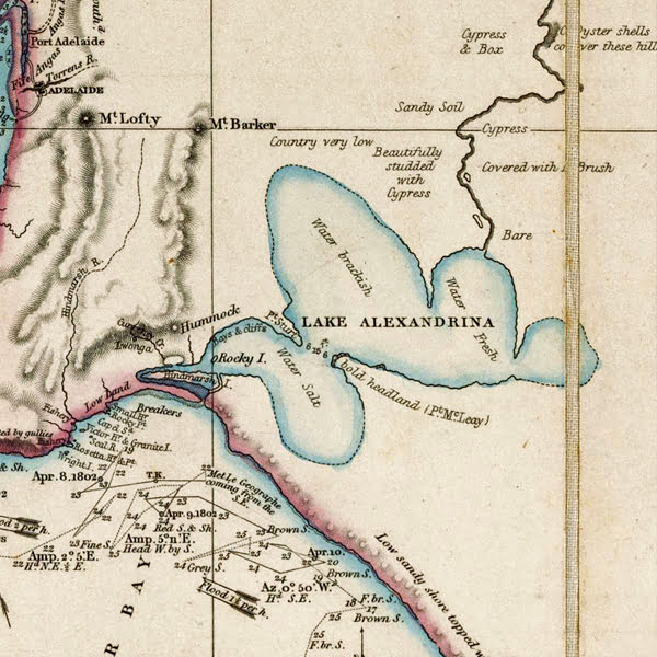
In fact the relevant scientific literature, as published in peer-reviewed journals, indicates that the Lower Lakes were estuarine prior to the erection of the viagra sea dykes, known locally as barrages. But it is also revealing to simply consider the history of the region. The first map of Lake Alexandrina, drawn by John Arrowsmith in 1838 based on reports of water quality from the famous British explorer Charles Sturt, shows the waters of Lake Alexandrina to transition from salt to brackish to fresh.
[This map has been copied from a zoom here http://nla.gov.au/nla.map-rm2633]
It appears that the South Australian government is also ignorant of the history of the lake with comment in important planning documents that: “The Lower Lakes have been predominantly freshwater for the last 7,000 years and that seawater ingressions, when they did occur, did not extend north of Point Sturt.”[3]
Point Sturt is clearly marked on the 1838 map. The map clearly shows that seawater ingressions extended into the main body of the lake turning the water brackish.
**********
[1] The report can be downloaded here: http://jennifermarohasy.com/publications/
[2] Water must mix in the Lower Lakes, says new Murray-Darling report. Adelaide Advertiser, February 24, 2012. Available online at http://www.adelaidenow.com.au/news/south-australia/water-must-mix-in-the-lower-lakes-says-new-murray-darling-report/story-e6frea83-1226281052851
[3] Securing the Future: A Long-term plan for the Coorong, Lower Lakes and Murray Mouth, June 2010, Government of South Australia. Available online as a 13mb pdf.


 Jennifer Marohasy BSc PhD is a critical thinker with expertise in the scientific method.

according to that map the Coorong and Lake Albert didn’t exist! is this correct?
It does seem odd that the politics wants to re invent or maybe simply ignore history.
The real problem is that what has been done at the bottom of the system has proven to be unsustainable.
Even though we have caps and significant amounts of ‘environmental’ water have been secured for the river AND that 3 YEARS of SA water was stored in upstream dams during the depth of the drought, SA politics is still crying foul.
Development and progress in SA has outstripped available State water storage and access.
Along with every other community, SA has altered its river environment. They have made some mistakes and they need to be fixed.
Re inventing history and pretending it is some one else’s fault is not going to fix anything.
SA also needs to concede that the LRM and the lakes are subject to an extra unique influence that makes it different to the rest of the MDB.
Anyone who lives downstream on any water course is of course affected by what happens upstream. That’s simply because water runs downhill. That does make SA vulnerable, but there is plenty of legislation and rules to cater for that.
But, to live near the ocean and then try to complain that it prevents them from being the same as the rest of the MDB is just denying simple geography and simple water physics.
The ocean and coastal weather patterns are simply too strong an influence.
Far better to work with it rather than trying to deny it.
Why doesn’t SA want to use it as advantage as other coastal communities do?
John, This is a very first map of the region. Discovery was slow and began with visits by Charles Sturt first from Sydney and then from Adelaide. He reported first on Lake Alexandrina and its water quality. Discovery of the Coorong and Lake Albert followed.
Thanks Jen.
What a great map Jen. And a great find too.
Isn’t it wonderful what a couple of casual notes like “salt water” and “brackish water” by the first explorer will do to establish the facts.
Observation data like that is priceless!
Dear Jen,
I have just noticed the delightful fact that the map that you reproduce carries the inscription “oyster shells cover these hills” for the Murray banks north of Lake Alexandrina.
This refers to very well known shallow marine deposits of Plio-Pleistocene age (say 5-2 Ma) that occur widely in this part of the basin. These oyster shellbeds are underlain by older marine strata back to early Miocene and older in age – see http://users.esc.net.au/~pereilly/geo.htm
Indeed, slightly earlier in geological history (in the Pliocene and early Pleistocene, ~5-2 million years ago) wide areas of the lower Murray Valley are underlain by marine sediments that include oyster shellbeds.
There is therefore no doubt that for the majority of its recent geological history the lower Murray Valley has represented a marine and estuarine gulf, which, being progressively fed with sediment during the Pleistocene climatic oscillations, had shrunk to become a restricted estuarine system at its lower end by the Late Pleistocene.
Some may think that this comment is irrelevant, and in a sense they would be right – insofar as the immediate roots of the presently perceived social-political problem lie in the Holocene history only. But wouldn’t it be wonderful if government Ministers had some understanding of deep history and also history.
All the best, Charlotte Ramotswe
No doubt you are fully aware of this Jennifer but for the Minister and his mates at the ABC. In Sturt’s account the “transition from fresh to salt” occurred “abreast of this point” which is clearly Pomanda, not Point Sturt as I have seen suggested elsewhere. Pomanda is the entrance to Lake Alexandrina so the map (while beautiful) exaggerates the extent of fresh water. See “GEOLOGICAL FORMATION” in Two Expeditions into the Interior of Southern Australia etc.
All the best,
RWTH